You are viewing our mobile site – view full site.
Visit our sponsors
The annual banquet of the Manitowoc County Lakes Association took place on Friday, October the 13th, hosted by Dan Dufek and the Larrabee Sportsman’s Club, who provided a delicious broasted chicken dinner and great company. MCLA members stepped up to provide an abundance of door prizes. The Annual Lake Stewardship awards were presented at the meeting.Annual Banquet Held on Oct. 13th, 2023
MCLA Annual Banquet held on Friday Oct. 13, 2023
.
Click on the maps to enlarge. Bathymetric Map Courtesy of and Copyright Sportsman’s Connection, based on Wisconsin DNR data. Watershed map courtesy of Manitowoc County Soil and Water Conservation Department. New! Zoom in even closer with this new interactive watershed mapping tool.
MCLA Lake Director: Gene Weyer
Directions: Hartlaub Lake Road, Town of Newton. Take Highway 42 South from Manitowoc 2 miles to English Lake Road. East on English Lake Road .3 miles to Hartlaub Lake Road. East on Hartlaub Lake Road to boat landing.
About Hartlaub Lake
- Condition: Fair/Eutrophic read more
Recreation
- Recreational Features: Blacktopped parking for 8 car/trailer units. Due to the soft bottom of the lake, a 60 foot port-a-pier has been installed for easier access. No potable water, no lighting, no restrooms.
- Boat ramp: Paved, 5% slope, Shallow <3 ft launch depth.
- ADA Accessibility Features: None.
- Restrictions: Electric motors only. Motorboat Prohibition, Slow-No-Wake Areas/Hours, Water Skiing Restrictions. See posted and Wisconsin boating handbook
- Note: Access road barricaded in winter.
- Manitowoc County Map and Photos: https://manitowoccountywi.gov/departments/parks/lake-access/hartlaub-lake/
Statistics
- Surface Area: 37 acres
- Depth: Max 60′, Mean 20′
- Shorelength: 1.2 mi
- Bottom: 0% sand, 10% gravel, 0% rock, 90% muck
- Type of Lake: Deep headwater drainage. What does this mean?
- Lat/Long: 44.04516470, -87.73757110
Aquatic Invasive Species Threats
- Verified: Curly-Leaf Pondweed (2010), Eurasian Water-Milfoil (2009), Hybrid Eurasian / Northern Water-Milfoil (2011)
Fishing
- Fish present: Bluegill and largemouth bass common; northern pike, walleye, perch, and other panfish present.
Regulations
- Open All Year
- Panfish: Daily bag limit 25. No min length.
- Catfish: Daily bag limit 10. No min length.
- Open May 6, 2023 – March 3, 2024:
- Largemouth/smallmouth bass: 14″ Limit 5.
- Northern Pike: 26″ Limit 2.
- Walleye: 15″ Limit 5.
- Motor Trolling is allowed with up to 3 hooks, baits, or lures, per angler.
- View Hartlaub Lake fishing regulations on DNR website and familiarize yourself with Wisconsin fishing: WDNR Hook & Line Guide
- Consumption Advisory: General Manitowoc County/Mercury. Click here.
Stocking and DNR Surveys
| DNR Fish Stocking Data | |||||
|---|---|---|---|---|---|
| Year | Species | Strain | Age Class | Number Stocked | Average Length (inches) |
| 2019 | WALLEYE | ROCK-FOX | SMALL FINGERLING | 1,225 | 1.70 |
| 2019 | WALLEYE | UNSPEC | LG FINGERLING | 300 | 8 |
| 2006 | WALLEYE | UNSPEC | LG FINGERLING | 605 | 6 |
| View more history | |||||
Condition: FAIR (2022) Source
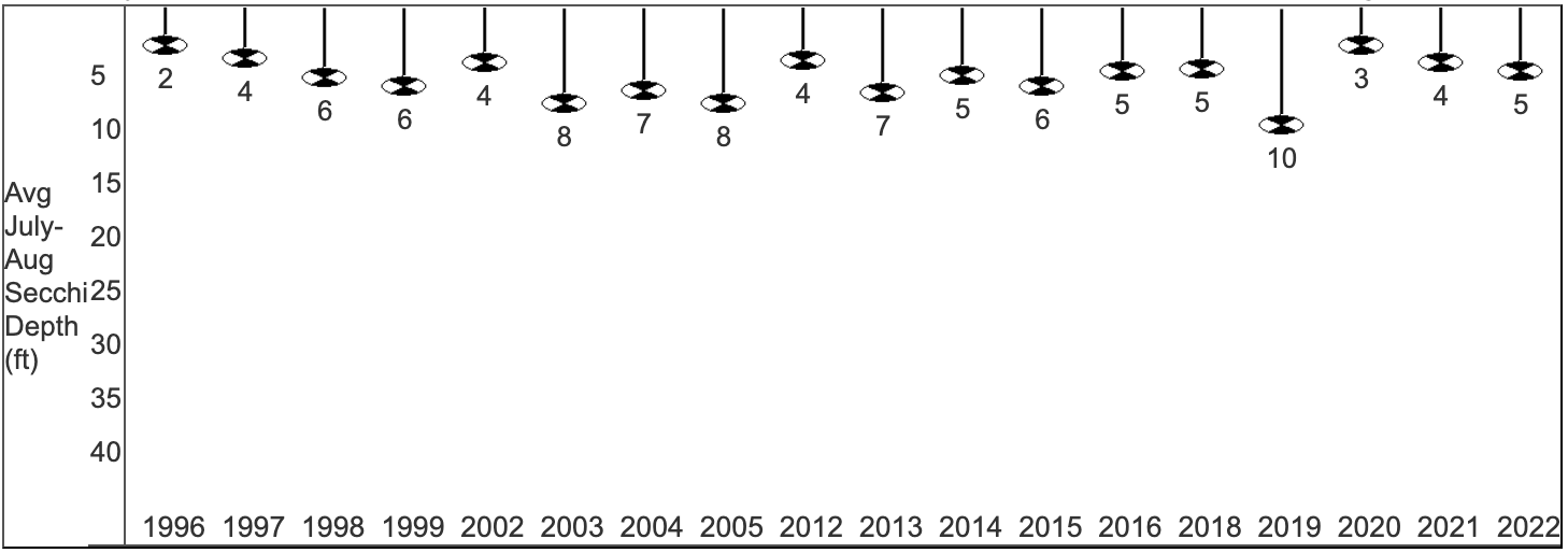
- 5-Year Average Trophic State: 62/Eutrophic
- Secchi Disk: Average summer reading 5 ft. (SE Georegion average 6.2 ft.) Summer (July/Aug) water was reported as MURKY and BROWN.
This suggests that the secchi depth may have been mostly impacted by suspended sediments.
- Chemistry (2022 – single reading):
Average summer Chlorophyll 26.1 µg/l (SE Georegion average of 24.7 µg/l).
Average summer Total Phosphorus 26.9 µg/l.
May experience noticeable algae blooms.
- Trophic State Index (TSI): 54/Eutrophic. What does this mean?
Eutrophic lakes are high in nutrients and contain large populations of plants, algae, and fish, which often grow to nuisance levels, and the fish species are generally tolerant of warm temperatures and low oxygen conditions. Phosphorus can fuel algae blooms. This TSI usually suggests decreased clarity, fewer algal species, oxygen-depleted bottom waters during the summer, plant overgrowth evident, warm-water fisheries (pike, perch, bass, etc.) only.
View TSI data graph on the DNR website