.
Click on the maps to enlarge. Bathymetric Map based on Wisconsin DNR data. Watershed map courtesy of Manitowoc County Soil and Water Conservation Department. New! Zoom in even closer with this new interactive watershed mapping tool.
Location: A PRIVATE lake in the Town of Newton.
About Kasbaum Lake
Lake Health
- 2022 Condition: Good/mesotrophic read more
Recreation
- Features: None; private lake.
- Restrictions: Only electric motors are allowed, Slow-No-Wake Areas/Hours, Water Skiing Restrictions. Read the Wisconsin handbook
Statistics
- Surface Area: 6 acres
- Depth: Max 68′
- Bottom: 0% sand, 0% gravel, 0% rock, 99% muck
- Shorelength: unknown
- Lake Type: Deep Seepage. Deep Seepage lakes stratify, or form separate layers of water, during the summer months and have no inlet or outlet.
- Lat/Long: 44.059529, -87.736075
Aquatic Invasive Species Threats
- None specifically reported.
Fishing
- Fish present: Abundant Panfish and Largemouth Bass.
Regulations
- Open All Year
- Panfish: Daily bag limit 25. No min length.
- Catfish: Daily bag limit 10. No min length.
- Open May 6, 2023 – March 3, 2024:
- Largemouth/smallmouth bass: 14″ Limit 5.
- Northern Pike: 26″ Limit 2.
- Walleye: 15″ Limit 5.
- Motor Trolling is allowed with up to 3 hooks, baits, or lures, per angler.
- View Kasbaum Lake fishing regulations on DNR website and familiarize yourself with Wisconsin fishing: WDNR Hook & Line Guide
- Consumption Advisory: General Manitowoc County/Mercury. Click here.
Stocking and DNR Surveys
- Fish Stocking Data: None available.
- DNR Fishing Report: None available.
- DNR Species Survey: None available.
Condition: GOOD (2022) Source
- 5-Year Average Trophic State: 45/Mesotrophic
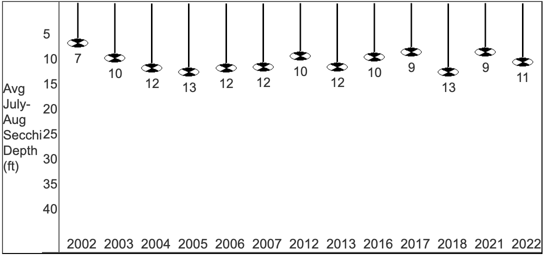
- Secchi Disk: Average summer reading 11 ft. (SE Georegion average 6.2 ft.)

- Chemistry:
Average summer Chlorophyll 2.5 µg/l. (SE Georegion average 24.7 µg/l).
Average summer Total Phosphorus 17.9 µg/l.
- Trophic State Index (TSI): 42/Mesotrophic. What does this mean?
Mesotrophic lakes contain moderate amounts of nutrients, and contain healthy, diverse populations of aquatic plants, algae, and fish. Occasional algae blooms may occur. If the lake is deep enough to stratify, the hypolimnion often becomes low in oxygen by the end of summer, and may result in some phosphorus release from the sediments. Mesotrophic lakes are characterized by moderately clear water, but have an increasing chance of low dissolved oxygen in deep water during the summer.
View TSI data graph on the DNR website

