.
Click on the maps to enlarge. Bathymetric Map Courtesy of and Copyright Sportsman’s Connection, based on Wisconsin DNR data. Watershed map courtesy of Manitowoc County Soil and Water Conservation Department. New! Zoom in even closer with this new interactive watershed mapping tool.
MCLA Lake Director: Dan Dufek
Location/Directions: North Lake Road, Town of Gibson. Take Interstate 43 North from Manitowoc to STH 147, East on STH 147 approximately 3 miles to Harpt Lake Road. North on Harpt Lake Road 1.75 miles to North Lake Road. West .2 miles to landing.
About Harpt Lake
Lake Health
- 2022 Condition: Fair/Eutrophic read more
Recreation
- Features: Parking for 4 car/trailer units is provided at the public access to this 31 acre lake, which includes a boat launch and fishing pier. An additional boat launch ramp, fishing piers and swimming beach are located on the east side of the lake at the Larrabee Sportsman’s Club. Lighting present. No restrooms.
- Nearby establishments: Larrabee Sportsman’s Club. Membership info
- Boat Ramp: Concrete ramp, 8% slope, 3 ft launch depth, boarding dock.
- Launch Fee: The daily fee is $5 and the seasonal fee is $20.
- ADA Accessibility Features: No. Not ADA accessible.
- Restrictions: Motor boats are permitted. Entire lake is “slow no-wake.” Wisconsin boating handbook
- Manitowoc County Map and Photos:
https://manitowoccountywi.gov/departments/parks/lake-access/harpt-lake/
Statistics
- Surface Area: 31.4 acres
- Depth: Max 54′, Mean 20′
- Shorelength: unknown
- Bottom: 5% sand, 20% gravel, 5% rock, 70% muck
- Type of Lake: Deep seepage (no inlet or outlet). What does this mean?
- Lat/Long: 44.29593080, -87.73401710
Aquatic Invasive Species Threats
- Verified: Eurasian Water-Milfoil (1994).
- Observed: Curly-Leaf Pondweed (2014), Purple Loosestrife (2014), Rusty Crayfish (2014).
Fishing
- Fish present: Largemouth bass, bluegill, black crappie are common, and walleye are present.
Regulations
- Open All Year
- Panfish: 25/10 Year-Round. 25 panfish may be kept, but no more than 10 of any one species. No minimum length limit.
Panfish fact sheet - Catfish: Bag limit 10. No min length.
- Panfish: 25/10 Year-Round. 25 panfish may be kept, but no more than 10 of any one species. No minimum length limit.
- Open May 6, 2023 – March 3, 2024:
- Largemouth/smallmouth bass: 14″ Limit 5.
- Northern: No length limit, bag limit 5.
- Walleye: 15″ Limit 5.
- Motor Trolling is allowed with up to 3 hooks, baits, or lures, per angler.
- View Harpt Lake fishing regulations on DNR website and familiarize yourself with Wisconsin fishing: WDNR Hook & Line Guide
- Consumption Advisory: General Manitowoc County/Mercury. Click here.
Stocking and DNR Surveys
- Harpt Lake Spring 2019 Comprehensive Fish Survey Report [PDF]
- Harpt Lake Electrofishing Survey 2012 [PDF]
DNR Conclusions from 2019 Survey:
-
Largemouth Bass are the dominant gamefish.
-
Walleye were caught in higher frequency in 2019 than during previous surveys.
-
Northern Pike exhibit good growth with above statewide average growth.
-
Bluegill continue to be the most abundant panfish.
-
Yellow Perch were the least commonly captured panfish despite several stockings since 2015.
It is recommended to:
- Halt DNR small fingerling Walleye stocking based on poor survival.
- Implement the recommendations from the ongoing Panfish Study to maintain a desirable panfish size distribution.
-
Encourage DNR, Manitowoc County and the Sportsmen’s Club to collectively find an alternate location for the public boat ramp or develop an off-road parking lot.
-
Continue to work with the local club to continue habitat projects.
-
Encourage land owners to implement recommendations found in their management plan to improve water quality by controlling runoff and exploring methods to reduce internal cycling of phosphorus.
| Fish Stocking Data | |||||
|---|---|---|---|---|---|
| Year | Species | Strain | Age Class | Number Stocked | Average Length (inches) |
| 2022 | YELLOW PERCH | UNSPEC | YEARLING | 2,798 | 4 |
| 2022 | FATHEAD MINNOW | UNSPEC | YEARLING | 18,800 | 1.5 |
| 2022 | WALLEYE | UNSPEC | LARGE FINGERLING | 1,500 | 8 |
| 2021 | WALLEYE | LAKE MICHIGAN | LARGE FINGERLING | 161 | 6.68 |
| 2019 | WALLEYE | ROCK-FOX | FINGERLING | 1,995 | 1.90 |
| 2019* | YELLOW PERCH | — | YEARLING |
2,800 |
4 |
| 2018* | WALLEYE | — | FINGERLING | 1,500 | 7-9 |
| 2018* | YELLOW PERCH | — | YEARLING |
2,800 |
4 |
| 2017 | WALLEYE | MISSISSIPPI HEADWATERS | SMALL FINGERLING | 1,126 | 1.70 |
| 2017* | YELLOW PERCH | — | YEARLING |
2,800 |
4 |
| 2015 | WALLEYE | LAKE MICHIGAN | SMALL FINGERLING | 1,349 | 1.70 |
| *Not a DNR project. Stocked by volunteers of the Larrabee Sportsmen’s Club | |||||
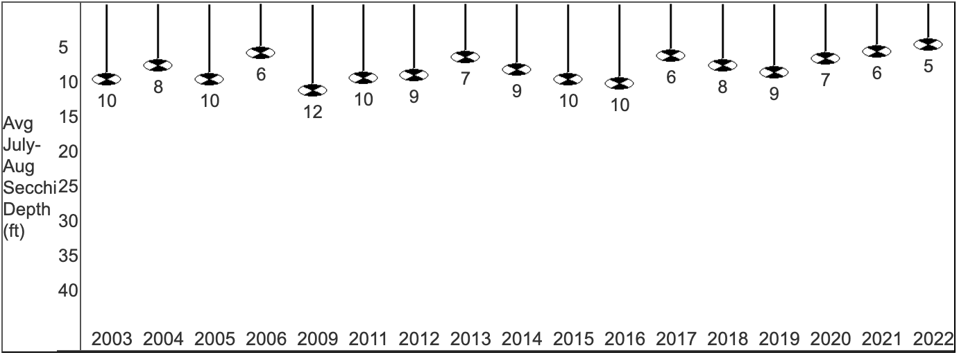
Condition: FAIR (2022) Source
- 5-Year Average Trophic State: 55/Eutrophic
- Secchi Disk: Average summer reading 5 ft. (SE Georegion average 6.2 ft.)
Summer (July/Aug) water was reported as MURKY and BROWN with algae blooms (would not swim).

- Chemistry:
Average summer Chlorophyll 20.9 µg/l (SE Georegion average 24.7 µg/l).
Average summer Total Phosphorus 32.7 µg/l.
May experience noticeable algae blooms.
- Trophic State Index (TSI): 58/Eutrophic. What does this mean?
This TSI usually suggests decreased clarity, fewer algal species, oxygen-depleted bottom waters during the summer, plant overgrowth evident, warm-water fisheries (pike, perch, bass, etc.) only.
View TSI data graph on the DNR website
Click on the maps to enlarge. Bathymetric Map Courtesy of and Copyright Sportsman’s Connection, based on Wisconsin DNR data. Watershed map courtesy of Manitowoc County Soil and Water Conservation Department. New! Zoom in even closer with this new interactive watershed mapping tool.
Other documents of interest:


Looks like someone loves their lake!