You are viewing our mobile site – view full site.
Visit our sponsors
Wilke Lake News
The annual event and awards presentation was held Oct 11 at the Viking Bow and Gun Club in Valders.2025 Annual Banquet
Click on the maps to enlarge. Bathymetric Map Courtesy of and Copyright Sportsman’s Connection, based on Wisconsin DNR data. Watershed map courtesy of Manitowoc County Soil and Water Conservation Department. New! Zoom in even closer with this new interactive watershed mapping tool.
MCLA Lake Director: Fred Ruszkiewicz
Wilke Lake Sanitary District recently had Stantec Consulting Services Inc. complete a Comprehensive Lake Management Plan. The plan is available below. Any questions may be directed to Scott Umland via manitowoccountylakesassoc@gmail.com.
Wilke_Lake_Management_Plan.pdf
Town of Schleswig Sanitary District No. 2 – Wilke Lake Web Page
Directions: County Highway JJ, Town of Schleswig. Take Highway 151 West from Manitowoc to CTH A, South on CTH A approximately 4.5 miles to Ucker Point Creek Road. Travel west on Ucker Point Creek Road 2 miles to Wilke Lake Road. Travel North to the Boat Landing.
About Wilke Lake
Lake Health
- 2025 Condition: Good/Oligotrophic read more
Recreation
- Features: The public access has parking space for 6-10 car/trailer units and a turn-around area. There is a picnic area with grills, a boat ramp, port-a-pier, lighting, and a toilet building. No potable water.
- Boat Ramp: Paved ramp, 7% slope, 3 ft launch depth, boarding dock.
- Launch Fee: The daily fee is $5 and the seasonal fee is $20.
- ADA Accessibility Features: No. Not ADA accessible. Ramp exceeds allowable slope.
- Restrictions: Motor boats are allowed. Operating restrictions on motorboats and water skiing are posted. Ordinance regulating littering, motorboat prohibition, noise levels, rafts, piers, ski jumps, slow-no-wake areas, slow-no-wake hours, swimming regulations, water skiing restrictions. Town of Schleswig Ordinances | Wisconsin boating handbook
- Manitowoc County Map and Photos: https://manitowoccountywi.gov/departments/parks/lake-access/wilke-lake/
Statistics
- Surface Area: 93 acres
- Depth: Max 21′, Mean 9′
- Bottom: 0% sand, 60% gravel, 0% rock, 40% muck
- Shorelength: 1.7 mi
- Lake Type: Deep seepage (no inlet or outlet), stratified. What does this mean?
- Lat/Long: 43° 57′ 59.45″ N / 87° 57′ 43.85″ W
Neither MCLA, the State of Wisconsin, the Department of Natural Resources, nor any of its employees shall be held liable for any improper or incorrect use of the information described and/or contained herein, and they assume no responsibility for anyone’s use of the information.
Aquatic Invasive Species Threats
- Verified: Curly-Leaf Pondweed (1993), Eurasian Water-Milfoil (1993).
Fishing
- Fish present: Abundant bluegill. Largemouth bass, northern pike, perch and stocked walleye present.
Regulations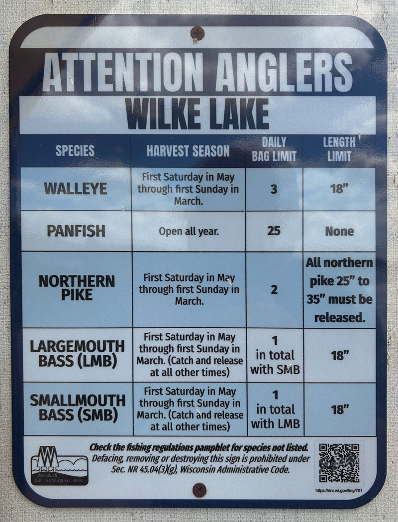
- Open All Year:
- Panfish: Daily bag limit 25. No min length.
- Catfish: Daily bag limit 10. No min length.
- Open May 2, 2026 to March 7, 2027:
- Largemouth and/or Smallmouth bass: 18” Limit 1 (total).
- Northern Pike: 2 Northern Pike of any length may be kept, pike 25-35” must be released.
- Walleye: 18” Limit 3.
- Motor Trolling is allowed with up to 3 hooks, baits, or lures, per angler.
- View Wilke Lake fishing regulations on DNR website and familiarize yourself with Wisconsin fishing: WDNR Hook & Line Guide
- Consumption Advisory: General Manitowoc County/Mercury. Click here.
Stocking and DNR Surveys
- Wilke Lake 2018 Comprehensive Fish Survey [PDF]
- Wilke Lake Fish Survey (2010) [PDF]
- Wilke Lake Comprehensive Lake Survey 1999 [PDF]
| Frequency of Fish Captured (2018): Number of fish caught for the following length categories (inches): |
|||||||||||
|---|---|---|---|---|---|---|---|---|---|---|---|
| species | 0-4″ | 4-6″ | 6-8″ | 8-10″ | 10-12″ | 12-16″ | 16-18″ | 18-24″ | Ave. length | Total | |
| Black Crappie | 1 | 10 | 2 | 9.1” | 13 | ||||||
| Bluegill | 133 | 88 | 79 | 1 | 4.5” | 301 | |||||
| Largemouth Bass | 1 | 4 | 10 | 19 | 5 | 2 | 11.8” | 41 | |||
| Northern Pike | 2 | 2 | 14 | 19.1” | 18 | ||||||
| Pumpkinseed | 8 | 14 | 31 | 10 | 6.2” | 63 | |||||
| Hybrid Sunfish | 1 | 4 | 2 | 3 | 6.1” | 10 | |||||
| Yellow Perch | 15 | 60 | 4.3” | 75 | |||||||
| Yellow Bullhead | 2 | 8 | 5 | 11.3” | 15 | ||||||
Survey Date: 05-18-2010/Gear: Electrofishing
| DNR Fish Stocking Data | |||||
|---|---|---|---|---|---|
| Year | Species | Strain | Age Class | Number Stocked | Average Length (inches) |
| 2025 | WALLEYE | LAKE MICH | LARGE FINGERLING | 461 | 7.7 |
| 2024* | WALLEYE | UNSPEC | LARGE FINGERLING | 1,047 | 7 |
| 2023 | WALLEYE | LAKE MICH | LARGE FINGERLING | 463 | 7.95 |
| 2022* | WALLEYE | UNSPEC | LARGE FINGERLING | 830 | 6 |
| 2022 | WALLEYE | LAKE MICH | YEARLING | 506 | 8.26 |
| 2019 | WALLEYE | ROCK-FOX | SMALL FINGERLING | 6,006 | 1.80 |
| 2018* | WALLEYE | UNSPEC | LARGE FINGERLING | 851 | 7 |
| 2017 | WALLEYE | MISSISSIPPI HEADWATERS | SMALL FINGERLING | 3,239 | 1.7 |
| 2016* | WALLEYE | UNSPEC | LARGE FINGERLING | 397 | 7 |
| 2015* | CRAPPIE | UNSPEC | LARGE FINGERLING | 497 | 6 |
| 2015 | WALLEYE | LAKE MICHIGAN | SMALL FINGERLING | 3,752 | 1.7 |
|
*Private stocking |
|||||
Condition: GOOD (2025) Source
New! Explore lake data with the DNR’s WEx Water Explorer Tool
(takes a minute to load)
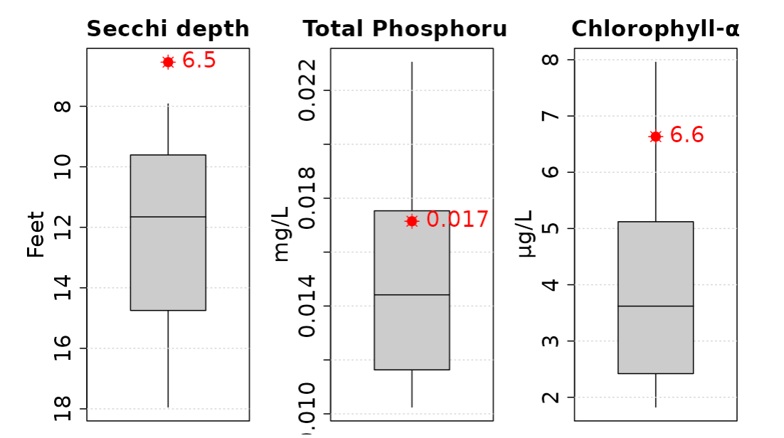
- 2025 Trophic State Index (TSI): 38/Oligotrophic. Based on Chlorophyll.
What does this mean?
This TSI usually suggests lakes are generally clear, deep, and cold. Nutrient levels are low, so fish that occur in oligotrophic lakes are often low in abundance, but large in size. Many oligotrophic lakes stratify in the summer—the lower layer is cold and supports cold-water fishes. - 2025 Secchi Disk: Average summer reading 8.2 ft. Summer water was reported as BROWN with minor aesthetic problems.
- 5-Year Average Chemistry:
Summer Chlorophyll 4.8 µg/l.
Summer Total Phosphorus 15.8 µg/l.
TSI: 46 Based on Chlorophyll readings. (Mesotrophic)
- Late summer trophic status compared to other deep seepage lakes.
Averages (red) from the last 10 years compared to other lakes (gray).
Click on the maps to enlarge. Bathymetric Map Courtesy of and Copyright Sportsman’s Connection, based on Wisconsin DNR data. Watershed map courtesy of Manitowoc County Soil and Water Conservation Department. New! Zoom in even closer with this new interactive watershed mapping tool.
Is there still muskie in this lake? I see some sites for this lake says it does. Thanks!
Hi Chris,
While there may be a few muskies in the various Manitowoc County Lakes, they are few and far between. The 2018 survey of Wilke, specifically, found none and suggested that the last stocked population was harvested as soon as they were legal. We saw this question recently posted on the Manty Fishing facebook group as well and there were some better answers there than we can give. You could contact someone at Manitowoc County Fish and Game who might have heard differently. Good luck!
MCLA