You are viewing our mobile site – view full site.
Visit our sponsors
Gass Lake News
The annual event and awards presentation was held Oct 11 at the Viking Bow and Gun Club in Valders. 2025 Annual Banquet
Click on the maps to enlarge. Bathymetric Map Courtesy of Wisconsin DNR. Watershed map courtesy of Manitowoc County Soil and Water Conservation Department. New! Zoom in even closer with this new interactive watershed mapping tool.
MCLA Lake Director: Richard Blashka
Directions: Gass Lake Road, Town of Newton. Take Highway 42 South from Manitowoc approximately 1 mile, turn right on Gass Lake Road and travel .75 miles to driveway on the right.
About Gass Lake
Lake Health
- 2025 Condition: Fair/Eutrophic read more
Recreation
- Features: No shoreline development. Blacktopped access road and parking area. Parking barriers and a gate over the entrance road have been installed. Combination fishing and launching port-a-pier with a small picnic area containing a table and grill. Parking space is available for 8 car/trailer units. No restrooms, no lighting, no potable water. Barricaded in winter.
- Boat Ramp: Paved, 7% slope, <3 ft launch depth, boarding dock.
- Launch Fee: The daily fee is $5 and the seasonal fee is $20.
- ADA Accessibility Features: Yes. The boarding dock, and route of travel to it, is ADA accessible. Steep–barricaded in winter.
- Restrictions: Electric motors only. Town of Newton | Wisconsin boating handbook
- Note: The access is barricaded during the winter because of the steep access road.
- Manitowoc County Map and Photos:
https://manitowoccountywi.gov/departments/parks/lake-access/gass-lake/
Statistics
- Surface area: 6.5 acres
- Shorelength: .5 mi
- Depth: Max 24′, Mean: 12′
- Bottom: 0% sand, 5% gravel, 0% rock, 95% muck
- Lake Type: Small drainage. What does this mean?
- Lat/Long: 44.05351650, -87.73057850
Aquatic Invasive Species Threats
- Verified: Curly-Leaf Pondweed (2016).
Fishing
- Fish present: Best known for largemouth bass, but northern pike and panfish including bluegill, perch and crappies are also found here.
Regulations
- Open All Year
- Panfish: Daily bag limit 25. No min length.
- Catfish: Daily bag limit 10. No min length.
- Open May 2, 2026 to March 7, 2027:
- Largemouth/smallmouth bass: 14″ Limit 5.
- Northern Pike: 26″ Limit 2.
- Walleye: 15″ Limit 3.
- Electric Motor Trolling is allowed with up to 3 hooks, baits, or lures, per angler.
- View Gass Lake fishing regulations on DNR website and familiarize yourself with Wisconsin fishing: WDNR Hook & Line Guide
- Consumption Advisory: General Manitowoc County/Mercury. Click here.
Stocking and DNR Surveys
- No DNR surveys available
- No recent stocking
Condition: FAIR (2025) Source
Explore lake data with the DNR’s WEx Water Explorer Tool
(takes a minute to load)
- 2025 Trophic State Index (TSI): 72/Hypereutrophic. Based on Chlorophyll.
What does this mean?
Decreased clarity, fewer algal species, oxygen-depleted bottom waters during the summer, plant overgrowth, warm-water fisheries (pike, perch, bass) only. - 2025 Secchi Disk: Average summer reading 7.0 ft. Summer water was reported as BLUE and CLEAR.
- 5-Year Average Summer Chemistry:
Summer Chlorophyll 32.6 µg/l.
Summer Total Phosphorus 58 µg/l.
TSI: 65 Based on Chlorophyll readings.
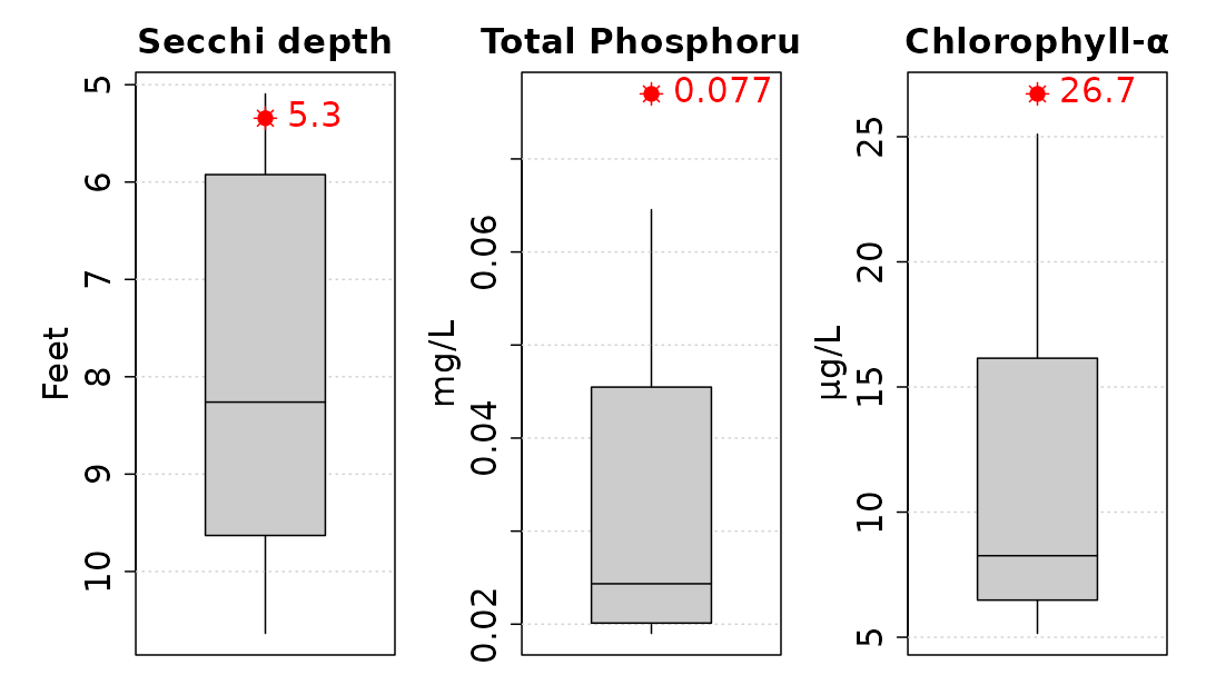
- 10-Year Average Late summer trophic status compared to other small drainage lakes. Averages (red) from the last 10 years compared to other lakes (gray).
We need lake volunteers. Learn more.
Congratulations on the new runoff project.