You are viewing our mobile site – view full site.
Visit our sponsors
Cedar Lake News
New regulations designed to balance fish populations will take effect across several lakes on April 1.New Fishing Regulations Effective April 1, 2026
Click on the maps to enlarge. NOTE THAT MAP SHOWS LAKE LEVELS 3+ FEET LOWER THAN CURRENT STABLE LEVELS. Bathymetric Map Courtesy of and Copyright Sportsman’s Connection, based on Wisconsin DNR data. Watershed map courtesy of Manitowoc County Soil and Water Conservation Department. Zoom in even closer with this new interactive watershed mapping tool.
MCLA Lake Directors: Mary Ann Waldbauer & Mike Strebe
Directions: Louis Corners Road, Town of Schleswig. Take Highway 151 West from Manitowoc to CTH A, South on CTH A approximately 6.5 miles to CTH XX. Travel west on CTH XX 1.5 miles to Louis Corners Road. Turn South on Louis Corners Road and follow approximately 1 mile. Boat Landing Located to the North.
Lake Organizations:
- Cedar Lake Improvement Association, Mary Ann Waldbauer – director. Website
- Town of Schleswig Sanitary District #1, Mike Strebe – director; Scott Otterson – alternate. Website
About Cedar Lake
Lake Health
- 2025 Condition: Excellent/Mesotrophic read more
Recreation
- Features: Road and launch area are blacktopped. 1-acre parking lot across Rockville Road, southwest of the access. Fishing area, port-a-pier, toilet building and lighting. No potable water.
- Boat Ramp: 2 launch lanes, concrete ramp, 11% slope, > 3 ft launch depth, boarding dock. No power loading. The main parking area is located across the road from the launch entrance. 11-15 vehicle and trailer stalls.
- Launch Fee: The daily fee is $5 and the seasonal fee is $20.
- ADA Accessibility Features: There is designated accessible parking at the launch site. The route of travel, and the transition, to the boarding dock, is not ADA accessible (May/2015).
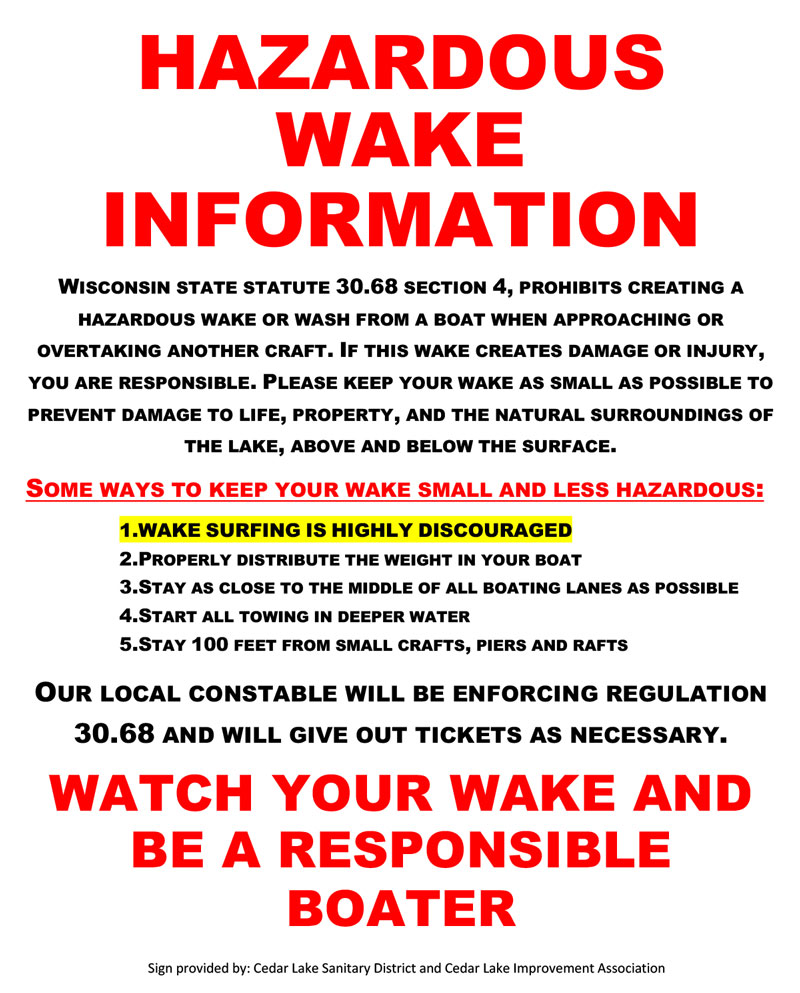
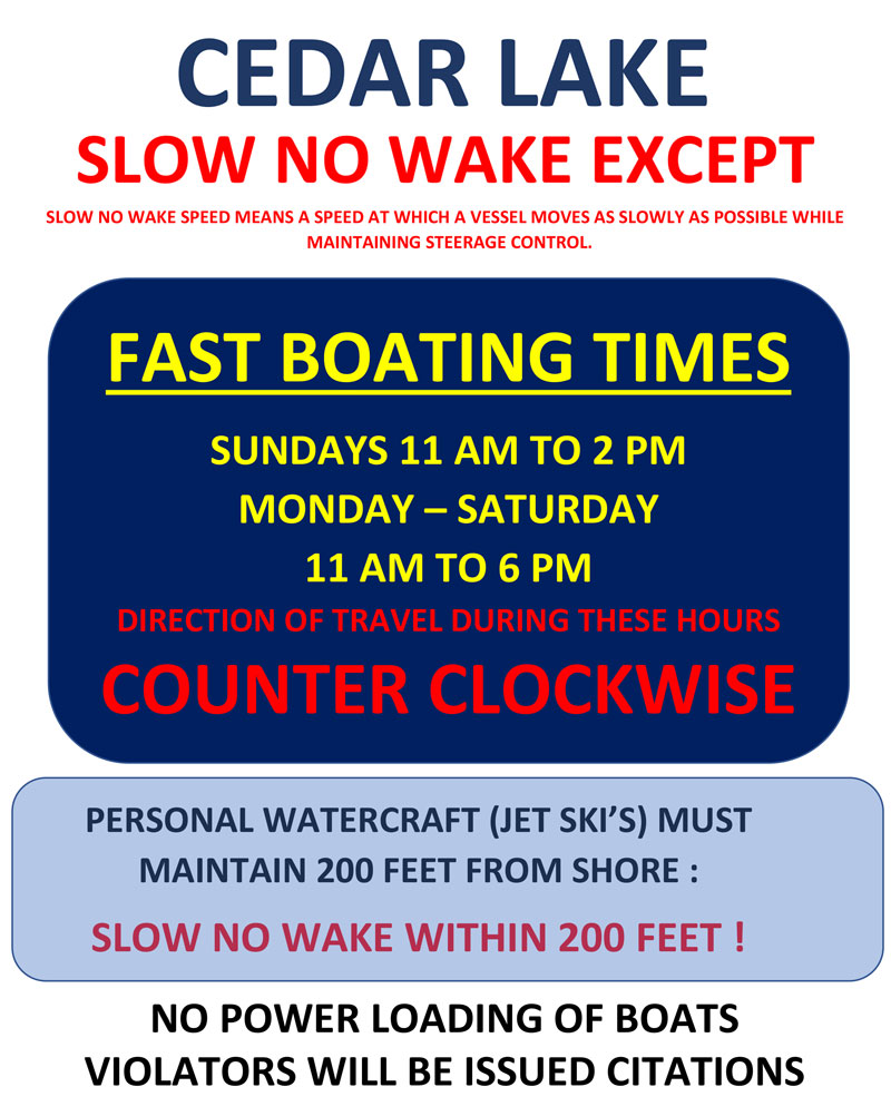
- Restrictions: Motor boats are allowed. Slow no wake except Sundays 11-2 and Mon-Sat 11-6. See signs posted at lake for current restrictions. Counterclockwise boating. No power loading. Littering, Noise Levels, Swimming, and Water Skiing Restrictions. Lake levels have been high. It is hopeful that boaters will fast boat near the center of the lake. Wave action adds to sediment suspension and erosion — please fast boat as far away from the shores as safe and practical. Town of Schleswig ordinance | Wisconsin boating handbook
Restrictions as posted, 2019
- Manitowoc County Map and Photos: https://manitowoccountywi.gov/departments/parks/lake-access/cedar-lake/
- Notes: This is the largest inland lake in Manitowoc County.
Statistics
- Surface Area: 150 acres
- Depth: Max 30′, Mean 12′
- Bottom: 10% sand, 45% gravel, 0% rock, 45% muck
- Shorelength: 4.1 mi
- Lake Type: Shallow seepage. What does this mean?
- Lat/Long: 43°55’31.5″N / 87°56’19.3″W
Aquatic Invasive Species Threats
- Verified: Banded Mystery Snail (2008), Eurasian Water-Milfoil (1993), Zebra Mussel (2001).
- Observed/Not Verified: Chinese Mystery Snail (2011), Rusty Crayfish (2010), Yellow Iris (2014).
Fishing
- Fish present: Northern pike, black crappie, and bluegill common. Yellow perch, walleye and largemouth bass present.
Regulations
- Open All Year
- Panfish: Daily bag limit 25. No min length.
- Bullhead: No minimum length limit; daily bag unlimited.
- Open May 3, 2025 to March 1, 2026:
- Largemouth/smallmouth bass: 14″ Limit 5.
- Northern Pike: 26″ Limit 2.
- Walleye: 15″ Limit 3.
- Motor Trolling is allowed with up to 3 hooks, baits, or lures, per angler.
- View Cedar Lake fishing regulations on DNR website and familiarize yourself with Wisconsin fishing: WDNR Hook & Line Guide
- Consumption Advisory: General Manitowoc County/Mercury. Click here.
Stocking and DNR Surveys
 Jason Breeggemann, WI-DNR Fisheries Biologist,
Presentation on 2022 Fisheries Survey
View PDF
| DNR Fish Stocking Data | |||||
|---|---|---|---|---|---|
| Year | Species | Strain | Age Class | Number Stocked | Average Length (inches) |
| 2025 | WALLEYE | UNSPECIFIED | LARGE FINGERLING | 1,000 | 8 |
| 2025 | WALLEYE | LAKE MICHIGAN | SMALL FINGERLING | 5,267 | 2.05 |
| 2024 | WALLEYE | LAKE MICHIGAN | SMALL FINGERLING | 4,713 | 1.96 |
| 2014 | WALLEYE | UNSPECIFIED | YEARLING | 1990 | 6 |
| 2013 | YELLOW PERCH | UNSPECIFIED | YEARLING | 2000 | 6 |
| View more history | |||||
DNR Fyke Net Survey Results, May 2022
- 6 walleyes all >23 inches, last stocked in 2013
- 18 pumpkinseed
- 5 yellow perch
- Northern pike: High density, slow growing fishery with few legal size fish
- Recommendations: Change regulation to slot limit
- Largemouth Bass: Moderate to high density with good size structure and average growth
- Recommendations: None
- Panfish: Crappie and bluegill found in moderate densities with moderate size structure and slow growth
- Recommendations: Regulation change?
- Cedar Lake Comprehensive Survey Report 2022 [PDF]
- Cedar Lake Comprehensive Survey Report 2016 [PDF]
- Cedar Lake Comprehensive Survey Report 2010 [PDF]
- Cedar Lake Comprehensive Survey Report 2006 [PDF]
Condition: EXCELLENT (2025) Source
New! Explore lake data with the DNR’s WEx Water Explorer Tool
(takes a minute to load)
- 2025 Trophic State Index (TSI): 41.3/Mesotrophic. Based on Chlorophyll.
What does this mean?
Mesotrophic lakes contain contain healthy, diverse populations of aquatic plants, algae, and fish. They are characterized by moderately clear water, but have an increasing chance of low dissolved oxygen in deep water during the summer. - 2025 Secchi Disk: Average summer reading 9.6 ft. Summer water was reported as GREEN and clear, sometimes with minor aesthetic problems. Green normally suggests algae however, with low chlorophyll readings, this lake may have been impacted by another factor, such as suspended marl.
- 5-Year Average Summer Chemistry:
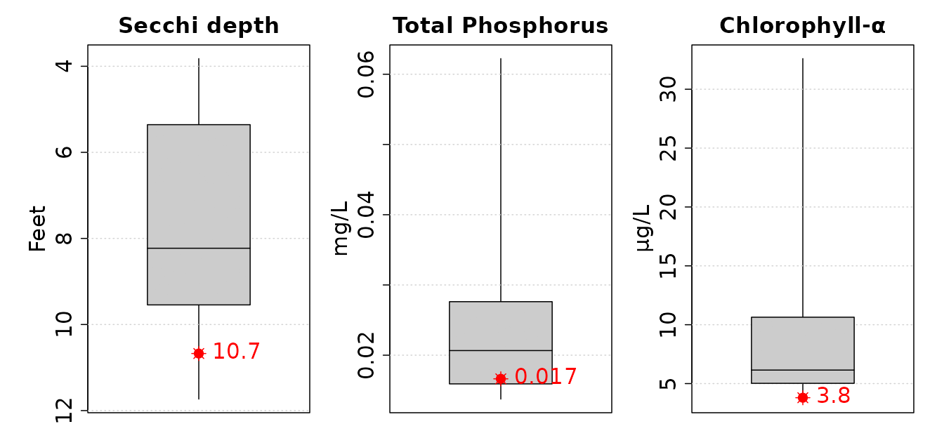
Summer Chlorophyll 4.0 µg/l.
Summer Total Phosphorus 16.1 µg/l.
TSI: 43.9 Based on Chlorophyll.
- 10-Year Average late summer trophic status compared to other shallow seepage lakes. Averages (red) from the last 10 years compared to other lakes (gray).
Where can I find regulations for building a dock and size limitations, shoreline improvements, and other things of that nature?
Thanks for the question.
With respect to the dock portion, I will refer you to the
DNR website.
Scroll to the section on Piers and look for the pier planner PDF to get started.
Shoreline improvements are normally administered through the county that you reside in. You can find Manitowoc County shoreline zoning info at: https://manitowoccountywi.gov/departments/planning-and-zoning/shoreland
I highly recommend contacting Reed Gaedtke, Code Administrator, to make an appointment to discuss any plans you may have in advance.
Reed Gaedtke
Manitowoc County Planning and Zoning Department
(920) 683-4185
ReedGaedtke@manitowoccountywi.gov
Hope this helps!
when is the Cedar Lake boat landing taken out for the end of the season?
Hi Dave,
The Planning & Park Manager at Manitowoc County gave us the following info to pass along to you.
The launch piers at Cedar and Wilke are now permanent and stay in year round. Not all piers have been upgraded to this permanent, floating design but quite a few have. The Manitowoc County launch piers that remain in year round are: Cedar, English, Harpt, Horseshoe, Long, Pigeon, Silver and Wilke.
Let us know if you have any other questions!
MCLA
Do you need to pay a launch fee for an inflatable kayak or inflatable i person pontoon boat where one is not using a boat trailer?
Thanks
Hi Dan,
Manitowoc County has a launch fee but it is not a mandate.
Funds collected are used to improve and maintain the launches.
If you are using the launch and parking lot it is appropriate to contribute but not mandatory.
Hope this helps.
MCLA
Are Sundays hours any different for wake seeing as it is 4th if July?
Hi Ashley.
We’ve checked with the municipality to be certain.
From Constable Ken Schuler:
The hours on Sunday for fast boating will be the same as always from 11AM to 2PM and the hours on Monday will also not change—they will be from 11AM to 6PM.
Enjoy your holiday!
MCLA
I would like to thank the Association for allowing use of the storage shed to cut lumber and fabricate boardwalk materials for a recent Ice Age Trail Alliance Mobile Skills Crew trail construction and improvement project. Dick Jens could not have been more accommodating. This two day assist was invaluable and we greatly appreciate it. Tim Malzhan, Trailway Director, Ice Age Trail Alliance.
Thank you Tim. Glad to be a tiny part of this big project! MCLA
Tim, The Sanitary District owns the shed and allowed your worthy project to take place. The Cedar Lake Improvement Association is a collection of forward-thinking lake residents that pay taxes to the Sanitary District and support many projects like yours that benefit more than just the lake residents. We look forward to working with you on future projects and hopefully the Ice Age Trail can be completed before the next Glacier comes through.
what are the swimming hours?
Hi Jane,
The beach on Cedar Lake is privately owned by The Lake House restaurant, so you would need to check with the establishment for beach hours and rules — (920) 894-4711. Rules and regulations pertaining to swimming from a boat are posted on the Town of Schleswig’s website here.
Hope this helps!
MCLA
Note that by Town of Schleswig Ordinance there is no swimming 100 feet from shore during fast boating hours for safety reasons. Also no scuba diving is allowed during fast boating hours.
The Lake House or Resort has been sold to a private party and there is no pubic beach access.
Is it a private lake or a dnr lake?
Hi Tom,
Cedar Lake is a Public lake with public access. The access point is a Manitowoc County Park.
Cedar Lake has private property surrounding it as well. Hope this helps!
I want my $5 back from last night 6/2/2020!! We paid our fee but were unable to launch because there was ZERO place to park truck and trailer. You ABSOLUTELY need MORE parking for vehicles w/trailers. We left and went to another lake and paid to launch AGAIN!!
Wendy, we noticed your request on the Manitowoc County Lakes Association website regarding the parking spaces at Cedar after you had paid a launch fee.
I understand the frustration. You need to contact the Manitowoc County Planning and Parks Department (920) 683-4185, as they collect the launch fees at all County lake accesses. I believe Pete Tarnowski from Planning and Parks can help you with the fee and explain the parking lot requirements.
I hope this helps you navigate the process.
Tom Ward,
President of the County Lakes Association
Hi Wendy,
The Cedar Lake boat launch and parking are a county park and although it’s access to our lake, it is not maintained by Cedar Lake Improvement Association or our Sanitary District from the town of Schleswig but rather the Manitowoc County Parks.
I’m sorry they did not have space to park after depositing the funds. I am aware that there are limited spaces for vehicles to park per a DNR Reg 1.91 which regulates the number of public boat launch parking spots per the size/acreage of said lake.
Manitowoc County did a great job last year updating the Cedar Lake boat launch and everyone has been appreciative of the work that went into it. There were parking spots added for boats as well as several new parking spots for cars without trailers (kayakers/canoes). Hope you have better luck next time and that we continue to have an amazing and warm summer.
Joshua Knuth, MCLA Cedar Lake Director
Why the changes at the ramp parking? There are now only a few designated places to park a trailer. Half the lot is for vehicles without trailers only. Basically, only about 6 people can launch their boats and park now. It really sucks because after driving all the way there, we usually have to just turn around and leave now because you can’t park anywhere. The access to the lake is effectively reduced to only a few individuals and that’s it. Is this becoming a private lake now?
We understand your concerns.
The new facilities allow for 9 boat and trailer spaces, 1 DNR/Sheriff spot and 8 car-only places. The number of spaces is regulated under Wisconsin state legislative code NR 1.91(5)b. which states: “The department has determined that granting permits for boating access on bodies of water where the maximum access standards are exceeded will materially impair navigation and is detrimental to the public interest.”
The chart in NR 1.91 shows inland lakes sized 100-499 acres with the following Maximum Public Boating Access: “One or more access sites which in total provide 1 car−trailer unit per 15 open water acres.”
For Cedar Lake at 136 acres the maximum number of car-trailer units is 9 (136 acres/15).
Since this is regulated by the state, neither the residents of Cedar Lake or the County of Manitowoc set these limits, we just follow the rules.
We hope you continue to come out to Cedar Lake. Please contact us again if you have further questions.
Do you need a launch permit for this lake?
Yes, fees are collected by honor system. The fees, which are collected by honor system, are $20/seasonal or $5/daily and go toward lake maintenance. There should be a station with envelopes at the launch where you can pay.
Apparently the NO Fast Boating restriction applies at 2 pm Sundays. No where is this notice, except at the boat ramp. It needs to be updated so people are aware.
Mr. Jeffery, thank you VERY MUCH for commenting on the need for better publicizing these boating restrictions. Your comment was forwarded to the lake director and we’ve now included images of the signs posted at the lake.
See http://www.townofschleswig.gov web page under department tab Sanitary District 1 Cedar Lake for several current and past fish reports from the DNR along with other water quality data and information. Note that the 1966 DNR map reflects a lake level 3+ feet lower than current relatively stable lake level conditions. One island is a submerged obstruction now.