You are viewing our mobile site – view full site.
Visit our sponsors
Bullhead Lake News
New regulations designed to balance fish populations will take effect across several lakes on April 1. New Fishing Regulations Effective April 1, 2026
Click on the maps to enlarge. Bathymetric Map Courtesy of and Copyright Sportsman’s Connection, based on Wisconsin DNR data. Watershed map courtesy of Manitowoc County Soil and Water Conservation Department. Zoom in even closer with this new interactive watershed mapping tool.
MCLA Lake Director: Ron Gerrits
Directions: County Highway JJ, Town of Rockland. Take County Highway JJ West from Manitowoc, through the un-incorporated area of Collins. Continue West on County Highway JJ approximately 3 miles. Driveway on the East side of the road.
About Bullhead Lake
Lake Health
- 2025 Condition: Poor/Hypereutrophic read more
Recreation
- Features: Parking for 16. Boat ramp, port-a-pier and toilet building. Picnic table and grill. No lighting.
- Boat Ramp: Concrete ramp, 4% slope, 3 ft launch depth, boarding dock.
- Launch Fee: The daily fee is $5 and the seasonal fee is $20. How to get a permit.
- ADA Accessibility Features: Yes. The boarding dock, and route of travel to it, is ADA accessible.
- Restrictions: 5 mph max, no wake, motorboats and water skiing restrictions posted.
Wisconsin boating handbook - Manitowoc County Map and Photos:
https://manitowoccountywi.gov/departments/parks/lake-access/bullhead-lake/ - Notes: One of the best fish populations in Manitowoc County. The positive effect of shoreland zoning is evident as one travels by boat.
Statistics
- Surface Area: 70 acres
- Depth: Max 40′, Mean 13′
- Bottom: 10% sand, 50% gravel, 0% rock, 40% muck
- Shorelength: 1.3 mi
- Lake type: Deep seepage (no inlet or outlet), stratified.
- Lat/Long: 44° 6′ 9.46″ N / 88° 2’25.31″ W
Aquatic Invasive Species Threats:
- Verified: Banded Mystery Snail (2009), Curly-Leaf Pondweed (2003), Eurasian Water-Milfoil (2005), Giant hogweed (2009).
Fishing
- Fish present: Northern pike, largemouth bass, and bluegill common. Walleye rare.
Regulations
- Open All Year:
- Panfish: Bag limit 10. No min length.
- Catfish: Bag limit 10. No min length.
- Open May 2, 2026 to March 7, 2027:
- Largemouth/smallmouth bass: 14″ Limit 5.
- Northern Pike: 26″ Limit 2.
- Walleye: 15″ Limit 3.
- Motor Trolling is allowed with up to 3 hooks, baits, or lures, per angler.
- View Bullhead Lake fishing regulations on DNR website and familiarize yourself with Wisconsin fishing: WDNR Hook & Line Guide
- Consumption Advisory: General Manitowoc County/Mercury. Click here.
Stocking and DNR Surveys
- Bullhead Lake Spring 2025 Fyke/Electrofishing Survey Results [PDF]
- Bullhead Lake Comprehensive Survey 2017 [PDF] (archived copy on MCLA website)
- Bullhead Lake Fish Survey 2011 [PDF] (archived copy on MCLA website)
DNR Conclusions and Recommendations from 2025 Survey:
- Northern pike: Moderate density population dominated by older fish. Monitor 3-5 years to ensure recruitment of young pike.
- Walleye: Low density population. Higher survival from 2023 stocking. Continue stocking and monitor.
- Largemouth bass: Very high-density population. Poor growth and size. Remove minimum size limit to reduce density and predation.
- Bluegill: Low–moderate density population. Good growth potential. Few very large bluegills.
- Black crappie and yellow perch: Only two of each species captured / excess predation. Change panfish regulation to a bag limit of 10 panfish on April 1, 2026
| DNR Fish Stocking Data | |||||
|---|---|---|---|---|---|
| Year | Species | Strain | Age Class | Number Stocked | Average Length (inches) |
| 2025 | WALLEYE | LAKE MICHIGAN | LG FINGERLING | 346 | 7.7 |
| 2025 | YELLOW PERCH | UNSPECIFIED | YEARLING | 300 | 7 |
| 2023 | WALLEYE | LAKE MICHIGAN | LG FINGERLING | 348 | 7.95 |
| 2022 | YELLOW PERCH | UNSPECIFIED | YEARLING | 465 | 7.5 |
| 2019 | WALLEYE | ROCK-FOX | SMALL FINGERLING | 4,633 | 1.80 |
| 2017 | WALLEYE | MISSISSIPPI HEADWATERS | SMALL FINGERLING | 2,432 | 1.70 |
| 2015 | WALLEYE | LAKE MICHIGAN | SMALL FINGERLING | 1,504 | 1.70 |
| 2013 | WALLEYE | MISSISSIPPI HEADWATERS | SMALL FINGERLING | 2,340 | 2.00 |
| View more history | |||||
Condition: POOR (2025) Source
Explore lake data with the DNR’s WEx Water Explorer Tool
(takes a minute to load)
- 2019 Update on Condition of Bullhead Lake by Ron Gerrits
- 2025 Trophic State Index (TSI): 64.5/Hypereutrophic. Based on Chlorophyll.
What does this mean?
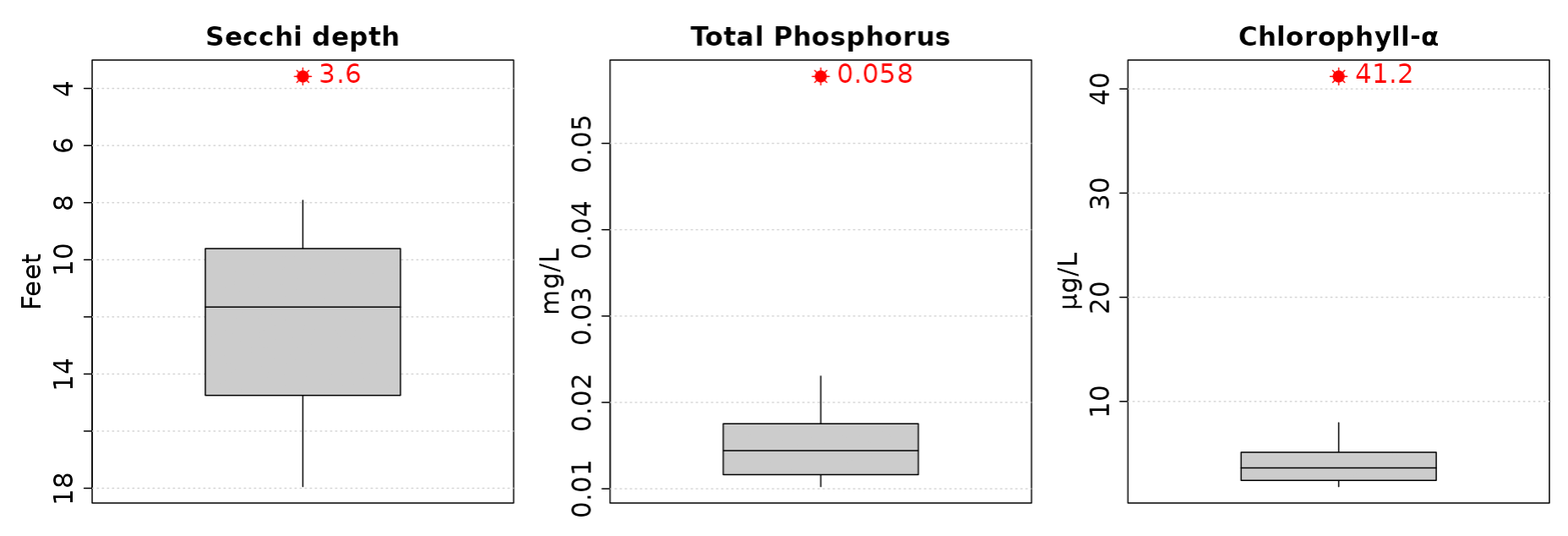
This number suggests decreased clarity, fewer algal species, oxygen-depleted bottom waters during summer, plant overgrowth, warm-water fisheries (pike, perch, bass, etc.) only. - 2025 Secchi Disk: Average summer reading 3.02 ft. Summer water was reported as GREEN and murky with algae present.
- 5-Year Average Summer Chemistry:
Summer Chlorophyll 40.5 µg/l.
Summer Total Phosphorus 54.9 µg/l.
TSI: 65.8 based on Chlorophyll readings.
- 10-Year Average late summer trophic status compared to other deep seepage lakes.
Averages (red) from the last 10 years compared to other lakes (gray).
Click on the maps to enlarge. Bathymetric Map Courtesy of and Copyright Sportsman’s Connection, based on Wisconsin DNR data. Watershed map courtesy of Manitowoc County Soil and Water Conservation Department. New! Zoom in even closer with this new interactive watershed mapping tool.
What a beautiful sunset photo!