You are viewing our mobile site – view full site.
Visit our sponsors
Silver Lake News
New regulations designed to balance fish populations will take effect across several lakes on April 1. New Fishing Regulations Effective April 1, 2026
.
Click on the maps to enlarge. Bathymetric Map Courtesy of and Copyright Sportsman’s Connection, based on Wisconsin DNR data. Watershed map courtesy of Manitowoc County Soil and Water Conservation Department. New! Zoom in even closer with this new interactive watershed mapping tool.
-
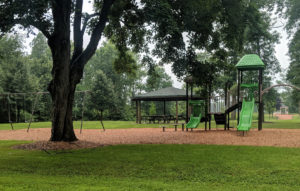
- Silver Lake playground. Photo: Vince Miller.
-
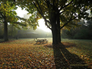
- Silver Lake picnic area. Photo: Vince Miller.
MCLA Lake Director: Brett Hubbartt
Directions: U.S. Highway 151, Town of Manitowoc Rapids. Take Highway 151 West from Interstate 43 approximately 1 mile. Driveway to the South.
About Silver Lake
Lake Health
- 2023 Condition: Poor/Eutrophic read more
Recreation
- Features: Excellent family picnic area, complete with a shelter, grills, tables and toilet building, as well as a new playground (2018). A new boat launch and pier were installed in 2017 for launching canoes, sailboats and rowboats. No lighting, no potable water. Great opportunity for families to fish from shore or by boat. The lake is home to large mouth bass, northern pike, perch and panfish. The wooded margins and the woodchip Kiranaqui trail along the creek offer the delights of hiking and bird watching, especially at the time of the spring and fall migration of warblers. Developed on 12 acres of land leased to Manitowoc County by the Franciscan Sisters of Christian Charity of Holy Family Convent.
- Boat Ramp: New ramp in 2017, 8% slope, 3 ft launch depth, boarding dock.
- Launch Fee: The daily fee is $5 and the seasonal fee is $20.
- ADA Accessibility Features: No. Not ADA accessible. The slope to the boarding dock exceeds the maximum allowable for ADA purposes.
- Restrictions: Electric motors only by Newton town ordinance.
Wisconsin boating handbook - Manitowoc County Map and Photos:
https://manitowoccountywi.gov/departments/parks/county-parks/silver-lake/
Statistics
- Surface Area: 73 acres
- Depth: Max 43′, Mean 16′
- Bottom: 0% sand, 15% gravel, 0% rock, 85% muck
- Shorelength: 2.3 mi
- Type of Lake: Deep lowland.
- Lat/Long: 44′ 4’23.87″N / 87′ 43′ 51.75″W
Aquatic Invasive Species Threats
- Verified: Hybrid Eurasian / Northern Water-Milfoil (2010), Rusty Crayfish (no date given), Eurasian Water-Milfoil (2008).
- Observed: Purple Loosestrife (2015)
Fishing
- Fish present: Northern pike, walleye, and bluegill common. Small perch present.
Regulations
- Open All Year
- Panfish: Bag limit 10. No min length.
- Catfish: Bag limit 10. No min length.
- Open May 3, 2025 – March 1, 2026:
- Largemouth/smallmouth bass: 18″ Limit 1 total.
- Northern Pike: 32″ Limit 1.
- Walleye: 18″ Limit 3.
- Motor Trolling is allowed with up to 3 hooks, baits, or lures, per angler.
- View Silver Lake fishing regulations on DNR website and familiarize yourself with Wisconsin fishing: WDNR Hook & Line Guide
- Consumption Advisory: General Manitowoc County/Mercury. Click here.
Stocking and DNR Surveys
| DNR Species Summary (2015): | ||||||||||
|---|---|---|---|---|---|---|---|---|---|---|
| Fyke Netting | Electroshocking | |||||||||
| species | Number | Length (ave.) | Number | Length (ave.) | ||||||
| Black Bullhead | 101 | 5.7-14.5″ (12.7″) | 3 | 3.6-13.8″ (10″) | ||||||
| White Sucker | 77 | 1 | – | |||||||
| Walleye | 18 | 9.9-25″ (19.2″) | 3 | 13.9-20″ (17.3″) | ||||||
| Golden Shiner | 6 | 1 | ||||||||
| Bluegill | 42 | 4.3-7.7″ (5.6″) | 13 | 2-7.1″ (5.1″) | ||||||
| Largemouth Bass | 1 | 19.6″ | 1 | 15.3″ | ||||||
| Northern Pike | 526 | 8-30.7″ (22″) | 19 | 11-28.9″ (20.7″) | ||||||
| Yellow Perch | 279 | 4.4-8″ (6″) | 141 | 4.7-8″ (5.4″) | ||||||
| Brown Bullhead | 17 | 12.4-14.3″ (13.1″) | 1 | 7.4″ | ||||||
| Pumpkinseed Sunfish | 5 | 3.7-4.4″ (4.1″) | 2 | 3.9-4.4″ (4.1″) | ||||||
| Black Crappie | 15 | 6-10″ (6.8″) | 2 | 3-3.2″ (3.1″) | ||||||
| Hybrid Sunfish | 1 | |||||||||
| Green Sunfish | 1 | 3.2″ | ||||||||
DNR Conclusions from 2015 Survey:
- Northern Pike numbers high despite the 2014-2015 winter kill. Size minimum regulation is working to produce an excellent Northern Pike fishery. Growth rate greater than state average.
- Winter kill severely reduced Walleye numbers and eliminated nearly all Bass. Recommended to continue stocking Walleye on an alternate year basis and Largemouth Bass for three consecutive years.
- Recommend working with lake and county residents to explore options to reduce the number and severity of overtopping events that have plagued the lake since 2004 and to address the low dissolved oxygen levels during winter months.
- Recommend monitoring invasive species, including Eurasian Water Milfoil.
- No carp captured but large carcasses noted.
- Over 1000 Double Crested Cormorants noted roosting on trees surrounding lake during survey
| DNR Fish Stocking Data | |||||
|---|---|---|---|---|---|
| Year | Species | Strain | Age Class | Number Stocked | Average Length (inches) |
| 2023 | WALLEYE | LAKE MICHIGAN | LARGE FINGERLING | 363 | 7.95 |
| 2022 | WALLEYE | LAKE MICHIGAN | YEARLING | 405 | 8.26 |
| 2020 | LARGEMOUTH BASS | UNSPEC | LARGE FINGERLING | 1,810 | 2.3 |
| 2019 | LARGEMOUTH BASS | UNSPEC | LARGE FINGERLING | 1,812 | 2.3 |
| 2019 | NORTHERN PIKE | MUD LAKE – MADISON CHAIN OF LAKES | SMALL FINGERLING | 2,063 | 2.70 |
| 2019 | WALLEYE | ROCK-FOX | SMALL FINGERLING | 4,749 | 1.80 |
Condition: POOR (2023) Source
New! Explore lake data with the DNR’s WEx Water Explorer Tool
(takes a minute to load)
- Last Reported Trophic State Index (TSI): 59/Becoming Eutrophic. (2023) Based on Chlorophyll. No more recent data is available.
What does this mean?
Eutrophic lakes are high in nutrients and contain large populations of plants, algae, and fish, which often grow to nuisance levels, and the fish species are generally tolerant of warm temperatures and low oxygen conditions. Phosphorus can fuel algae blooms. This TSI usually suggests blue-green algae become dominant and algal scums are possible, extensive plant overgrowth problems possible. - Secchi Disk: The most recent summer reading, taken in July 2024, was 3.0 ft. A report of 3.5 in July 2023 states that water was GREEN. This suggests that the secchi depth may be mostly impacted by algae.
- 5-year Average Summer Chemistry:
Summer Chlorophyll 37.7 µg/l.
Summer Total Phosphorus 80 µg/l.
TSI: 62 based on Chlorophyll readings.
- 10-year Average late summer trophic status compared to other deep lowland lakes. Averages (red) from the last 10 years compared to other lakes (gray).

Under Recreational Features it says the majority of the fish that are caught are rough fish, this is not true any more since 2001 the lake was completely killed and the creek was diverted from going into the lake and all game fish were replanted, over 2000,000 of them. The park also offers a 1100 foot wood chip trail in the woods and along the creek. There is also a playground for the children (put in in 2018). The concret boat landing is gone and a new boat launch and pier installed (2017).
I am one of the volunteers that have worked with the reopening of the park since 2006
Thanks Vincent! Grateful for the info! We will make those edits ASAP and if you have a photo of the new playground, we’d love to include it?