You are viewing our mobile site – view full site.
Visit our sponsors
Shoe Lake News
Annual Banquet Held on Oct. 13th, 2023
MCLA Annual Banquet held on Friday Oct. 13, 2023
The annual banquet of the Manitowoc County Lakes Association took place on Friday, October the 13th, hosted by Dan Dufek and the Larrabee Sportsman’s Club, who provided a delicious broasted chicken dinner and great company. MCLA members stepped up to provide an abundance of door prizes.
The Annual Lake Stewardship awards were presented at the meeting.
Click on the maps to enlarge. Bathymetric Map Courtesy of and Copyright Sportsman’s Connection, based on Wisconsin DNR data. Watershed map courtesy of Manitowoc County Soil and Water Conservation Department. New! Zoom in even closer with this new interactive watershed mapping tool.
Directions: Shoe Lake Rd., Schleswig. Take WI-42 S from Manitowoc to left on Lax Chapel Rd in Schleswig to right on Shoe Lake Rd.
About Shoe Lake
Lake Health
- Condition: Good/Mesotrophic read more
Recreation
- Features: Port-a-pier and boat ramp. 105 feet of frontage with parking for 15 car/trailer units. A picturesque lake with very little shoreline development. Perfect place for rowboating and canoeing. No restrooms, no lighting, no potable water.
- Boat Ramp: Metal grate, 9% slope, >3 ft launch depth, boarding dock.
- Launch Fee: The daily fee is $5 and the seasonal fee is $20.
- ADA Accessibility Features: No. Not ADA accessible. The transition to the boarding dock is not ADA accessible (May/2015).
- Restrictions: Electric motors only. Regulated by Town of Schleswig. Wisconsin boating handbook
- Manitowoc County Map and Photos:
https://manitowoccountywi.gov/departments/parks/lake-access/shoe-lake/
Statistics
- Surface Area: 9 acres
- Depth: Max: 34′, Mean 22′
- Bottom: 0% sand, 25% gravel, 0% rock, 75% muck
- Shorelength: 0.6 miles
- Lake Type: Small seepage. What does this mean?
- Lat/Long: 43° 56′ 43.12″ N / 87″ 59′ 12.59″W
Aquatic Invasive Species Threats
- Verified: Eurasian Water-Milfoil (2012), Hybrid Eurasian / Northern Water-Milfoil (2012)
Fishing
- Fish present: Bluegill, largemouth bass, black crappie abound. Perch present.
Regulations
- Open All Year
- Panfish: Daily bag limit 25. No min length.
- Catfish: Daily bag limit 10. No min length.
- Open May 6, 2023 – March 3, 2024:
- Largemouth/smallmouth bass: 14″ Limit 5.
- Northern Pike: 26″ Limit 2.
- Walleye: 15″ Limit 5.
- Motor Trolling is allowed with up to 3 hooks, baits, or lures, per angler.
- View Shoe Lake fishing regulations on DNR website and familiarize yourself with Wisconsin fishing: WDNR Hook & Line Guide
- Consumption Advisory: General Manitowoc County/Mercury. Click here.
Stocking and DNR Surveys
| Summary of DNR Species Sampling (1995-2007-2018) | ||||
|---|---|---|---|---|
| Number caught 1995 |
Number caught 2007 |
Number caught 2018 | Length 2018 |
|
| Largemouth Bass | 138 | 42 | 5 | 6.3-16″ (ave. 11.9″) |
| Northern Pike | 1 | |||
| Black Crappie | 12 | 4 | 51 | 6-8.1″ (ave. 6.7″) |
| Bluegill | 41 | 20 | 14 | 2.8-5.3″ (ave. 6.7″) |
| Yellow Perch | 7 | 3 | 25 | 4.6-6.8″ (ave. 5.5″) |
| Sunfish | 1 | 1 | ||
| Yellow Bullhead | 1 | 5 | 4.6-10.7″ (ave. 8.1″) | |
| Golden Shiner | 3 | |||
DNR Conclusions from 2018 Survey
- Largemouth Bass numbers are down substantially. Many missing year classes indicate many years of poor recruitment.
- Bluegill numbers are down.
- Black Crappie and Yellow Perch have increased in number. Both are more tolerant to low dissolved oxygen.
- Poor recruitment of Largemouth Bass and other fish may be due to high exploitation of a fishery limited by a small littoral zone or more likely from episodes of poor water quality.
- Stocking may be required to restore the fish populations.
No record of DNR Fish Stocking
Condition: GOOD (2022) Source
- 5-Year Average Trophic State: 48/Mesotrophic
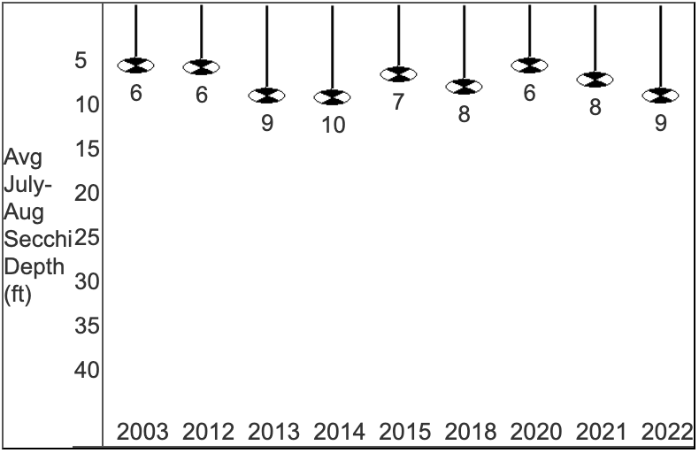
- Secchi Disk: Average summer reading 9.4 ft. (SE Georegion average 6.2 ft.)
Typically the summer (July-Aug) water was reported as CLEAR and BLUE.
- Chemistry:
Average summer Chlorophyll 4.2 µg/l (SE Georegion average 24.7 µg/l).
Average summer Total Phosphorous 13.1 µg/l. - Trophic State Index (TSI): 46/Mesotrophic. What does this mean?
This TSI usually suggests decreased clarity, fewer algal species, oxygen-depleted bottom waters during the summer, plant overgrowth evident, warm-water fisheries (pike, perch, bass, etc.) only.
View TSI data graph on the DNR website