You are viewing our mobile site – view full site.
Visit our sponsors
Horseshoe Lake News
The annual banquet of the Manitowoc County Lakes Association took place on Friday, October the 13th, hosted by Dan Dufek and the Larrabee Sportsman’s Club, who provided a delicious broasted chicken dinner and great company. MCLA members stepped up to provide an abundance of door prizes. The Annual Lake Stewardship awards were presented at the meeting.Annual Banquet Held on Oct. 13th, 2023
MCLA Annual Banquet held on Friday Oct. 13, 2023
Click on the maps to enlarge. Bathymetric Map Courtesy of and Copyright Sportsman’s Connection, based on Wisconsin DNR data. Watershed map courtesy of Manitowoc County Soil and Water Conservation Department. New! Zoom in even closer with this new interactive watershed mapping tool.
MCLA Lake Director: Robert Christian
Location/Directions: County Highway XX. Take Highway 42 South from Manitowoc, West on County Highway XX approximately 3 miles. Driveway to the South.
About Horseshoe Lake
Lake Health
- 2021 Condition: Fair/Eutrophic (2022 not available) read more
Recreation
- Features: Manitowoc County maintains an 8.5 acres park at Horseshoe Lake. An attractive picnic area with grills, tables and playground equipment has been developed on the hillside northwest of the parking lot. A picnic area with a grill and a small shelter and toilet are located near the parking lot on the lower level. The lake access has a pier, which is used for both launching and fishing. No lighting, no potable water.
- Restrictions: Electric motors only. Slow-No-Wake Areas. See posted. Wisconsin boating handbook
- Boat Ramp: Concrete ramp, 11% slope, >3 ft launch depth, boarding dock.
- Launch Fee: The daily fee is $5 and the seasonal fee is $20.
- ADA Accessibility Features: Yes. The boarding dock, and the route of travel to it, is ADA accessible.
- Manitowoc County Map and Photos:
https://manitowoccountywi.gov/departments/parks/county-parks/horseshoe-lake/
Statistics
- Surface Area: 22 acres
- Depth: Max 54′, Mean 25′
- Bottom: 0% sand, 5% gravel, 0% rock, 95% muck
- Shorelength: 1.2 mi
- Type of Lake: Deep seepage. Two-story lake. What does this mean?
- Lat/Long: 43.93071890, -87.89153320
Aquatic Invasive Species Threats
- Verified and vouchered: Eurasian Water-Milfoil (1971); verified: Curly-Leaf Pondweed (2005)
Fishing
- Fish present: Rainbow trout, largemouth bass, and bluegill common. Northern pike and walleye present. Other panfish present.
Regulations
- Open All Year
- Panfish: Daily bag limit 25. No min length.
- Catfish: Daily bag limit 10. No min length.
- Open May 6, 2023 – March 3, 2024:
- Largemouth/smallmouth bass: 14″ Limit 5.
- Northern Pike: 26″ Limit 2.
- Walleye: 15″ Limit 5.
- Motor Trolling is allowed with up to 3 hooks, baits, or lures, per angler.
- View Horseshoe Lake fishing regulations on DNR website and familiarize yourself with Wisconsin fishing: WDNR Hook & Line Guide
- View the Wisconsin Trout Regulations at DNR
- Consumption Advisory: General Manitowoc County/Mercury. Click here.
Stocking and DNR Surveys
| DNR Fish Stocking Data | |||||
|---|---|---|---|---|---|
| Year | Species | Strain | Age Class | Number Stocked | Average Length (inches) |
| 2022 | RAINBOW TROUT | ERWIN | YEARLING | 780 | 8.5 |
| 2021 | RAINBOW TROUT | ERWIN | YEARLING | 999 | 8.9 |
| 2020 | RAINBOW TROUT | ERWIN | LARGE FINGERLING | 2,100 | 4.4 |
| 2019 | RAINBOW TROUT | ERWIN | LARGE FINGERLING | 2,200 | 6.60 |
| 2017 | RAINBOW TROUT | ERWIN | LARGE FINGERLING | 2,200 | 5.80 |
| 2016 | RAINBOW TROUT | ERWIN | LARGE FINGERLING | 3,006 | 5.90 |
| 2015 | RAINBOW TROUT | ERWIN | LARGE FINGERLING | 2,933 | 6.00 |
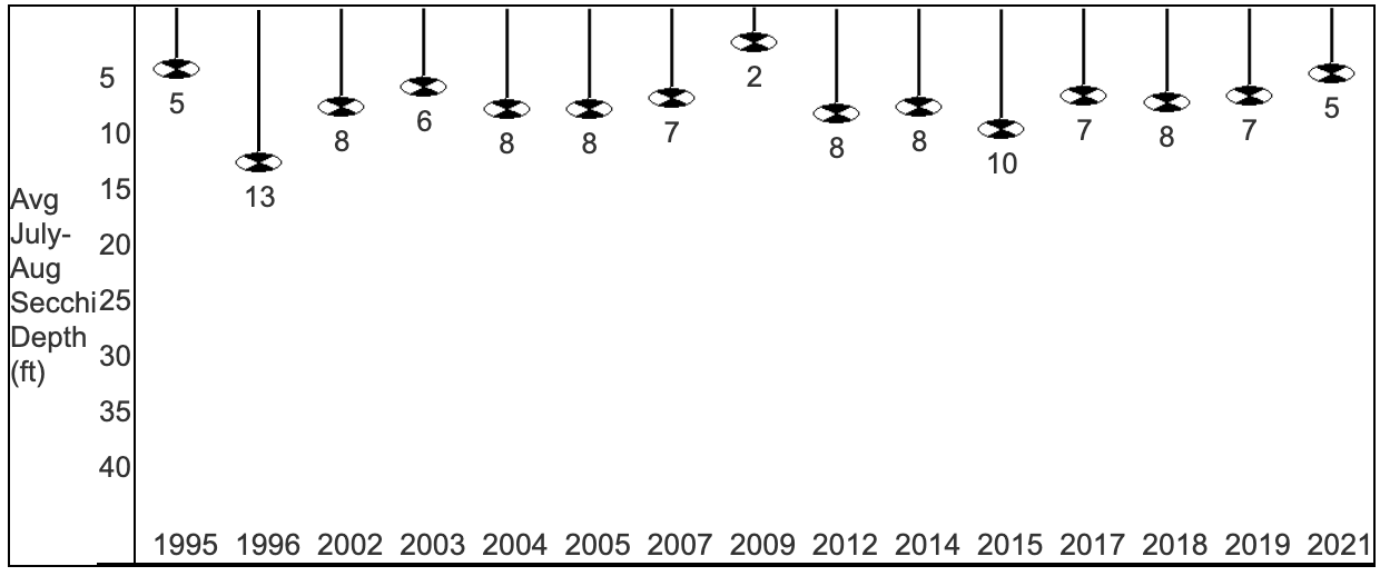
Condition: FAIR (2021) Source 2022 data not available
- 5-Year Average Trophic State: 50/becoming Eutrophic
- Secchi Disk: Average summer reading 5 ft. (SE Georegion average 7.1 ft.)
Typically the summer (July-Aug) water was reported as MURKY and GREEN. This suggests that the secchi depth may be mostly impacted by algae.
- Chemistry (2021):
Average summer Chlorophyll 14.1 µg/l (SE Georegion average 20.9 µg/l).
Average summer Total Phosphorus 36.2 µg/l.
May experience noticeable algae blooms.
- Trophic State Index (TSI) (2021): 55/Eutrophic. What does this mean? Lakes becoming eutrophic: decreased clarity, fewer algal species, oxygen-depleted bottom waters during the summer, plant overgrowth evident, warm-water fisheries (pike, perch, bass, etc.) only.
View TSI data graph on the DNR website
Are launch fees required for Manitowoc Lakes for kayaks? Sheboygan County doesn’t require fees for kayaks, canoes, or paddle boards, but I can’t seem to find a definitive answer for Manitowoc lakes.
Sorry for the delay. We don’t want to give misinformation. We’ll email you!
Boat launch fees in Manitowoc County go directly back into the launch facilities. The suggested fee is $5 per day or $20 per season. Although there is no policing, if you enjoy using the lakes, your donation is welcome! Donations help the county provide supplies to reduce the spread of invasives and make recreational use of the lakes a great experience for everyone!