You are viewing our mobile site – view full site.
Visit our sponsors
Carstens Lake News
Public welcome! April 25 meeting topics: Carstens Lake project, DNR panfish regulations. April 25 Meeting Agenda Announced
Click on the maps to enlarge. Bathymetric Map Courtesy of and Copyright Sportsman’s Connection, based on Wisconsin DNR data. Watershed map courtesy of Manitowoc County Soil and Water Conservation Department. Zoom in even closer with this new interactive watershed mapping tool.
MCLA Lake Director: Brian Robley
Directions: Google maps. Town of Newton. Take Highway 42 South approximately 4 miles from Manitowoc to Carstens Lake Rd. East .5 miles to Karbon Ln to the North.
About Carstens Lake
Lake Health
- 2023 Condition: Poor/Hypereutrophic read more
- Read about the Carsten’s Lake Water Quality Project
Recreation
- Features: Parking for 11-15 car/trailer units, boat ramp, boarding dock, public toilet, lighting. No potable water.
- Boat Ramp: Paved, 7% slope, 3 ft launch depth, boarding dock.
- Launch Fee: The daily fee is $5 and the seasonal fee is $20.
- ADA Accessibility Features: Handicapped parking spot available. The approach to the boarding dock is not ADA accessible (Nov 2016).
- Restrictions: Electric motors only. Slow-No-Wake Areas/Hours, Water Skiing Restrictions. Read the Wisconsin handbook
- Manitowoc County Map and Photos:
https://manitowoccountywi.gov/departments/parks/lake-access/carstens-lake/ - Notes: Several years ago, the DNR poisoned off the lake and a fish weir was installed within the inlet stream to block off the spawning runs of rough fish from Lake Michigan. Adult northern pike and bass have been planted to restock the lake.
Statistics
- Surface Area: 21 acres
- Depth: Max 28′, Mean 12′
- Bottom: 0% sand, 0% gravel, 0% rock, 99% muck
- Shorelength: .8 mi
- Lake Type: Deep headwater drainage, stratified.
- Lat/Long: 44° 1′ 25.51″ N / 87° 45′ 57.25″ W
Aquatic Invasive Species Threats:
- Verified: Curly-Leaf Pondweed (1993), Eurasian Water-Milfoil (1993), Hybrid Eurasian / Northern Water-Milfoil (2012).
Fishing
- Fish present: Bluegill and Largemouth Bass.
Regulations
- Open All Year
- Panfish: Daily bag limit 25. No min length.
- Catfish: Daily bag limit 10. No min length.
- Open May 6, 2023 – March 3, 2024:
- Largemouth/smallmouth bass: 14″ Limit 5.
- Northern Pike: 26″ Limit 2.
- Walleye: 15″ Limit 5.
- Motor Trolling is allowed with up to 3 hooks, baits, or lures, per angler.
- View Carstens Lake regulations on DNR website and familiarize yourself with Wisconsin fishing: WDNR Hook & Line Guide
- Consumption Advisory: General Manitowoc County/Mercury. Click here.
Stocking and DNR Surveys
| Summary of DNR Species Sampling (2015) | ||
|---|---|---|
| Number | Size range | |
| Bluegill | 120 | 2.2-6.3″ |
| Black Crappie | 13 | 6.5-7.9″ |
| Green Sunfish | 1 | 4″ |
| Largemouth Bass | 47 | 7-18.3″ |
| Yellow Perch | 1 | 4.3″ |
| Total | 182 | |
| DNR Fish Stocking Data | |||||
|---|---|---|---|---|---|
| Year | Species | Strain | Age Class | Number Stocked | Average Length (inches) |
| 2014 | YELLOW PERCH | UNSPECIFIED | YEARLING | 2,367 | 6 |
| 2014 | YELLOW PERCH | UNSPECIFIED | LARGE FINGERLING | 150 | 4 |
| 2014 | FATHEAD MINNOW | UNSPECIFIED | ADULT | 19,997 | 2 |
| 2011 | YELLOW PERCH | UNSPECIFIED | ADULT | 2,000 | 6 |
| 1999 | NORTHERN PIKE | LAKE PUCKAWAY | LARGE FINGERLING | 105 | 7.40 |
| 1999 | LARGEMOUTH BASS | UNSPECIFIED | SMALL FINGERLING | 1,050 | 1.20 |
| View more history | |||||
Condition: POOR (2023) Source
New! Explore lake data with the DNR’s WEx Water Explorer Tool
(takes a minute to load)
- 2023 Trophic State Index (TSI): 70/Hypereutrophic. Based on Chlorophyll.
What does this mean?
This number suggests blue-green algae become dominant and algal scums are possible, extensive plant overgrowth problems possible. - 2023 Secchi Disk: The most recent summer reading, taken in June 2020, was 5.2 ft. The water was reported as MURKY and GREEN. This suggests that the secchi depth may be mostly impacted by algae.
- 5-year Average Chemistry:
Summer Chlorophyll 68 µg/l.
Summer Total Phosphorus 109 µg/l.
TSI: 71 based on Chlorophyll readings.
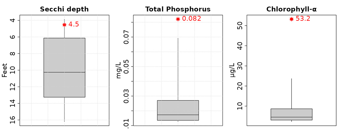
- Late summer trophic status compared to other deep headwater lakes.
Averages (red) from the last 10 years compared to other lakes (gray).
Click on the maps to enlarge. Bathymetric Map Courtesy of and Copyright Sportsman’s Connection, based on Wisconsin DNR data. Watershed map courtesy of Manitowoc County Soil and Water Conservation Department. Zoom in even closer with this new interactive watershed mapping tool.